Drones in natural calamity management
8-9 minutes approx
Introduction
Recent advancements in UAV technology have revolutionized the way we respond to natural disasters. Unmanned Aerial Vehicles (UAVs) equipped with cutting-edge features have become invaluable tools in disaster management. In this article, we'll explore the practical applications and technical advancements that make UAVs essential in disaster scenarios, accompanied by real-world examples of their effectiveness.
UAVs in Search and Rescue: Speed and Precision
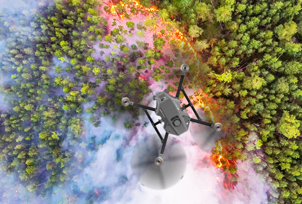
UAVs have transformed the speed and precision of search and rescue operations during disasters. Equipped with GPS technology, cameras, and thermal imaging sensors, these UAVs provide real-time situational awareness. GPS ensures precise location tracking, while cameras and thermal sensors capture high-resolution imagery even in challenging conditions.
Data Collection and Mapping: Technical Prowess
UAVs stand out in data collection, courtesy of their advanced sensors and imaging capabilities. Equipped with high-resolution cameras, they efficiently capture detailed aerial images of disaster-affected regions. These images serve multiple purposes, from assessing damage to creating 3D maps that aid disaster preparedness and response, further facilitated by cutting-edge tools like Pix4D. Pix4D offers a comprehensive suite of drone mapping and photogrammetry software tools, complete with a flight app, desktop application, and cloud platforms, enhancing the efficiency and effectiveness of data analysis and utilization in disaster scenarios.
Advanced Payload Delivery Systems: Versatility and Precision
UAVs boast versatile payload capabilities, allowing them to transport various types of equipment, including emergency supplies, medical kits, and communication devices. These payload delivery systems are engineered for precision and safety, ensuring critical supplies reach their intended destination without compromising the well-being of rescue teams or survivors.
Aeronautical Advancements: Navigating Complexity
In the context of disaster relief, UAVs have witnessed significant aeronautical advancements. They are designed to operate in adverse weather conditions, displaying resilience against strong winds and precipitation. Their agility and maneuverability enable them to navigate complex terrains, including disaster-stricken areas riddled with debris and obstacles.
Data Transmission and Real-time Communication: Information at Your Fingertips
UAVs come equipped with advanced communication systems that facilitate real-time data transmission. This capability allows disaster response teams to receive critical information promptly, improving decision-making and resource allocation. UAVs can also serve as communication relays, ensuring affected regions maintain connectivity, even when traditional communication infrastructure is compromised.
Autonomous Flight and Automation: Streamlined Operations
The autonomous nature of UAVs is a key technical feature. These UAVs can be pre-programmed to follow specific flight paths or waypoints, enabling them to operate autonomously. Some UAVs are even equipped with obstacle avoidance systems, enhancing their safety and ability to navigate challenging environments.
Future Technological Advancements: A Promising Horizon
As technology continues to advance, UAVs' role in disaster management will evolve further. Developments in artificial intelligence and machine learning will enable UAVs to analyze data in real-time, providing actionable insights for disaster response. Enhanced battery life and energy-efficient propulsion systems will extend flight durations, increasing UAVs' endurance in disaster zones.
Conclusion
In the dynamic landscape of disaster response and relief, Indo Wings shines as a symbol of innovation and effectiveness. The cutting-edge UAV technology demonstrates a commitment to precision and effectiveness. UAVs are engineered for speed and accuracy, equipped with advanced GPS, high-resolution cameras, and thermal imaging sensors. These capabilities empower search and rescue operations by swiftly pinpointing survivors' locations and assessing disaster-stricken areas. Moreover, It’s proficiency in data collection and mapping, as evident from website, enhances disaster preparedness and response. These UAVs play a pivotal role in creating accurate 3D maps, streamlining payload delivery, and contributing to the swift distribution of critical supplies.
Indo Wings: dedication to technological excellence position them as a valuable
partner in mitigating the impact of natural disasters and safeguarding
communities.
Back to all Blog